The Illinois Department of Transportation publishes bicycle maps of each of its nine districts across the state. In addition to many trails, the map includes comfort level ratings (“Bicycle Level of Service”) calculated for all the roadways in its database.
IDOT’s database include almost all rural roads, but only major roads in urban areas. As a result, the maps are an excellent resource for rural bicycling, but less so in urban areas – where cyclists generally use quieter roads not in IDOT’s database.
Ride Illinois and the City of Aurora have developed a free 24″ x 18.25″ map which suggests routes for bicycle travel throughout Aurora. The front of the map shows trails and preferred road routes. The back of the map provides resources and useful information for safer biking, plus bus routes and bikes on transit information.
Printed copies of the map are available at Aurora City Hall or download the pdfs below.
Ride Illinois has also produced brochures with helpful tips on bike commuting to the Aurora Downtown Metra Station and the Route 59 Metra Station. Topics include selecting a route (map provided), parking and locking your bike, clothing and cleaning up, and safety tips.
Ride Illinois and Champaign County Bikes have partnered on maps suggesting routes for bicycle travel throughout the Champaign-Urbana area. The back of the map provides resources and useful information for safer biking. Download the 2014 edition:
The City of Chicago’s Bicycle Program publishes a map of the city’s ever-expanding network of designated bike routes. The map is frequently updated as new bike routes are established.
Visit the City of Chicago’s website for the most current bike maps.
Ride Illinois, in partnership with the Decatur Bicycle Club (DBC) and the Decatur Urbanized Area Transportation Study (DUATS), has created a first edition bike map which suggests routes for bicycle travel throughout the Decatur area. The back of the 20″ x 18″ map provides resources and useful information for safer biking.
Grab your bike, bring along a map, and discover where in Kane County the Bikeway System can take you! Visit cities and villages along the five major regional trails within Kane County: The Fox River Trail, The Great Western Trail, The Virgil Gilman Trail, the four spurs of The Illinois Prairie Path, and the developing Mid-County Trail. These regional trails are connected to an extensive local bikeway system that can take you across Kane County, through our historic downtowns, along the scenic Fox River, and by our farmlands, prairies, and open space.
Ride Illinois has developed a fifth edition (2019) of this map which suggests routes for bicycle travel throughout the Quad Cities area. The back of the map provides resources and useful information for safer biking.
Ride Illinois has developed this map which suggests routes for bicycle travel throughout the Rockford area. The back of the map provides resources and useful information for safer biking.
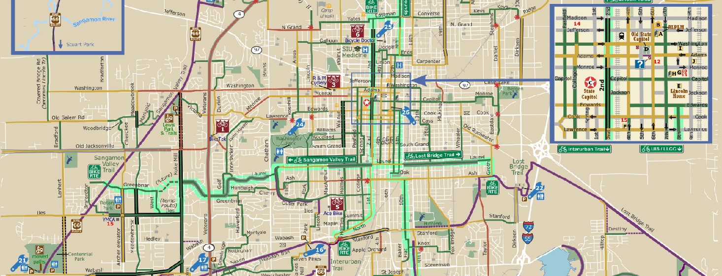
Ride Illinois has developed this map which suggests routes for bicycle travel throughout the Springfield area. The back of the map provides resources and useful information for safer biking.
Below is a list of links to other bike maps and trail guides in Illinois. Ride Illinois has also produced four route guides to help you plan longer bike rides and tours of the Grand Illinois Trail, Mackinaw Valley Trail, Mississippi River Trail, and Route 66 Trail.
Rails-to-Trails Conservancy’s Trail Link
Chicago Area Mountain Bikers (CAMBr) Trail Guides
Friends of Constitution Trail Maps
Forest Preserves of Cook County Maps
Kickapoo State Park Mountain Bike Trails
Lake County Forest Preserve Trail Maps
Lake County DOT’s “Bike Lake County” map, app
Madison County Transit Trails Map
Midewin National Tallgrass Prairie – Trails Map